SIGNS OF WARMER WEATHER HEADING INTO THE SECOND LAST WEEK OF MAY
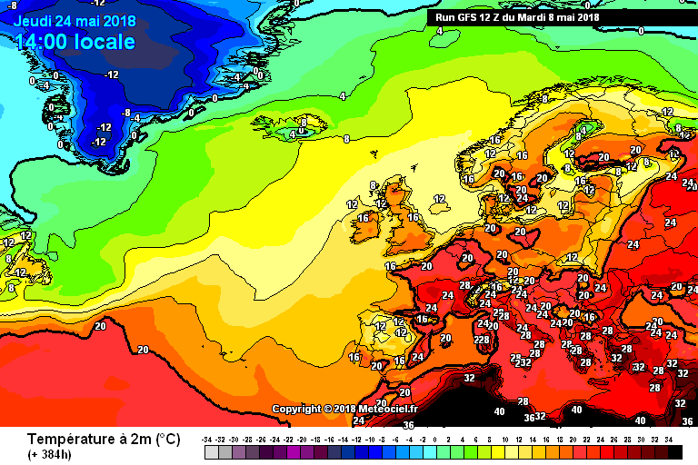
Gfs model run from meteociel.fr
Looking at some of the models over the past 48hrs there have been hints that the weather might turn a little warmer coming into the 2nd last week and last week of May.
The latest Gfs model run is leading the way this evening with the Ecmwf showing hints of the same scenario over the last few hours. This evening the Ecmwf model does not look as strong but that's why we have to look at the models with caution at this stage and not get carried away.
May so far has seen one good warm spell with temperatures getting as high as 23C in the east of Ireland (Phoenix park Dublin) over the Bank holiday weekend with a record breaking temperature for early May record in the England of 28.7°C that temperature recorded in Northolt smashing 23.6°C record previous to that.
Continues below
The reason for it turning cooler again this week and over the weekend is due to the jet steam moving back southward bringing weak areas of low pressure near by which will lead to windy and wet conditions especially on Wednesday and Friday of this week.
Anywhere away from the east of Ireland over the Bank holiday there was less sunshine and was a lot cooler. In the northwest on Sunday there was a high of 19.7°C recorded at Finner Donegal, 13.2°C in Belmullet Mayo, 11.3°C at Roches point Cork, 20.8°C Gurteen Tipperary & 18°C in Belfast.
Temperatures between now and the 18th of May will be average for May or close to average.
Rainfall will also be average or just above especially along western parts of Ireland between now and 18th of May and average or just below over the rest of the UK.
The Gfs model run was showing last night and this morning that high pressure would build around the 20th of May bringing warm and dry weather but at this stage for my liking its still outside the time frame to forecast.
For now all I can do is watch until I feel its in a better time frame to issue some confidence in any warmer spell but the good side is that there are signs of something on the horizon at the end of May into the start of June
I will continue to keep a eye on the coming runs over the next week and update on any changes.
Gfs model run from meteociel.fr


