FLASH NEWS
SATURDAY 6TH APRIL 2024
UPDATE 12:49hrs: A max wave height of 57 feet has been recorded of the southwest coast in the past hour at the M3 buoy with the risk of coastal flooding this afternoon in the south, southwest, west and northwest.
UPDATE 12:37hrs: ESB networks say 34,000 homes and businesses are with out power this lunchtime with Cork, Kerry, Mayo and Galway worse hit.
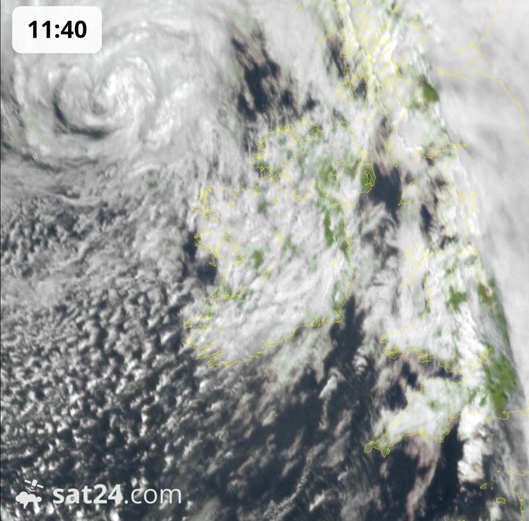
UPDATE 11:58hrs: The center of Storm Kathleen is now visible of the northwest of Ireland and as it moves north them winds will intensify with the strongest wind feild to the south and south and west of the low.
UPDATE 11:47hrs: A gust of 145km/hr recorded at Mayo sailing club in westport which is in the red warning cretria.
UPDATE 11:30hrs: Storm Kathleen is now really starting to intensify across the western and northwestern part of Ireland this morning with gusts of 112km/hr recorded both at Mace Head, Galway and Belmullet, Mayo
Anything above 110km/hr is in the Orange warning.
Note that the 166km/hr showing on this map is a false reading over county down.
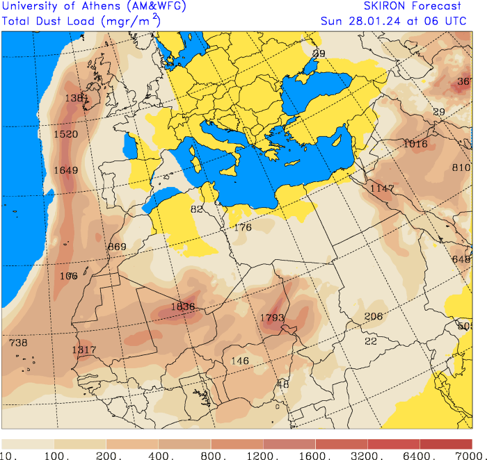
SAHARA DUST SET TO PUSH UP ACROSS IRELAND THIS WEEKEND
Sahara dust is set to move up across Ireland today in a mid airmass and will sit across Ireland through Sunday.
A band of rain will move in from the Atlantic on Sunday morning and will was some of that dust out of the air and will leave deposits on surfaces like cars and windows as a example.
THURSDAY 25TH JANUARY 2024
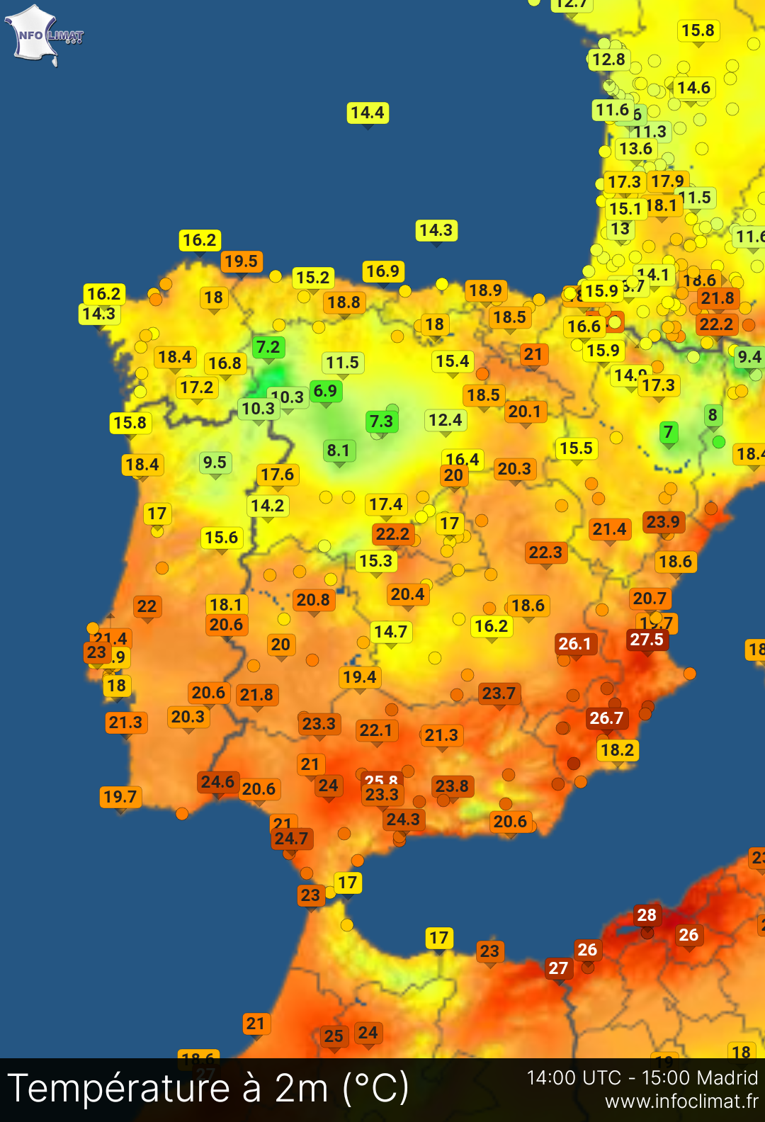
Spain records its second highest January temperature in 38 years
Temperatures in southern Spain today reached just over 28C - the second-highest value recorded in January since 1985.
AEMET, Spain's state meteorological agency, reported that maximum temperatures recorded at one observatory in the Mediterranean region of Murcia hit 28.2C.
At another, provisional data showed the temperature peaked at 28.5C.
The unusually warm weather came close to breaking records, becoming the second-highest value recorded at one observatory for January in 38 years, the agency said in a post on X.
TUESDAY 23RD JANUARY 2024
WINDS WILL PEAK ACROSS DONEGAL BETWEEN 10PM AND 2AM
Storm Jocelyn update 20:50hrs
The worst of the winds from storm Jocelyn will now transfer northwards across Donegal. From around 10pm winds will start to increase and remain fairly strong across the county until 2am but should start to ease from around 3am Wednesday morning.
Some of them stronger winds will also be felt across western and northern parts of Derry.
From around 11pm the worst of the winds should have past Galway and Mayo.
SLIGO - TREE DOWN
Storm Jocelyn update 20:20hrs
🦺There is a large tree down on the R292 Strandhill to Ransboro Road at Culleenamore.
Motorists are advised to avoid this road until our crews remove the tree.
NEW TOP GUST OF 122KM/HR RECORDED AT MACE HEAD GALWAY - FINNER SOUTH DONEGAL RECORDS ITS HIGHEST GUST
Storm Jocelyn update 19:31hrs
We have a new strongest gust recorded in the last hour again from Mace Head in Galway with a gust of 122km/hr. There was also a mean wind speed of 76km/hr which is in the Orange Criteria.
Finner in south Donegal has also recorded its strongest wind gust of 108km/hr.
🔶WHAT IS A STATUS ORANGE🔶
Infrequent and dangerous weather conditions which may pose a threat to life and property.
Prepare yourself in an appropriate way depending on location and activity. All people and property in the affected areas can be significantly impacted.
Check your activity/event and delay or cancel as appropriate.
Wind
Widespread mean speeds between 65 and 80km/h
Widespread gusts between 110 and 130km/h
NEW TOP GUST OF 115KM/HR RECORDED AT MACE HEAD GALWAY
Storm Jocelyn update 18:30hrs
A new top gust of 115km/hr has been recorded at Mace head, Galway now as them strongest winds pass by western parts of Galway and Mayo transferring into Donegal tonight.
The below map shows the highest wind gusts so far around Ireland from storm Jocelyn.
NEW POWER OUTAGES THIS EVENING DUE TO STORM JOCELYN
Storm Jocelyn update 18:05hrs
On top of the current power outages from storm Isha were the northwest and west was badly effected we now have fresh power outages in parts of the northwest.
Reports of new power outages in Raphoe & Donegal Town
STRONGEST GUST SO FAR RECORDED AT MALIN HEAD DONEGAL
Storm Jocelyn update 17:35hrs
A wind gust of 112km/hr recorded in Malin Head, Donegal in the last hour which is the strongest so far. This is in a orange warning cretria.
WINDS ON THE RISE IN THE WEST AND NORTHWEST
Storm Jocelyn update 16:40hrs
Storm Jocelyn has arrived with winds now starting to pick up across the western half of Ireland gusting into the 90km/hr mark.
Wind gusts in the region of 90km/hr to 110km/hr are within a yellow criteria.
Wind gusts in the region of 110km/hr to 130km/hr are within a orange criteria.
More than 130km/hr are in the red warning criteria.
https://www.donegalweatherchannel.ie/weather-warnings
Winds now starting to become stronger
Storm Jocelyn update 15:35hrs
Storm Jocelyn has arrived with winds slowly starting to pick up. Winds will pick up this evening and tonight across the west & northwest particularly across Mayo, Galway and Donegal.
Winds will not be as strong as storm Isha but still will likely cause some damage especially due to the amount of trees and structures that have been damaged by storm Isha with the full clean up not finished yet.
ESB crews have done brilliant work connecting people back to the power grid. Still around 45,000 are without power down from 235,000.
View all the latest warnings here 👉https://www.donegalweatherchannel.ie/weather-warnings
Monday 22nd JANUARY 2024
3 homes badly damaged in Donegal by lightning
22/01/2024 - 18:10hrs
3 homes have been badly damaged in Newtown Cunningham by lightning.
2 homes have had extensive fire damage with the 3rd home receiving internal damage with electrical appliances been damaged.
Just before 3pm a Thunderstorm moved down across Donegal with heavy rainfall, hail and lightning.
It also left many with power again especially in Inishowen.
93,000 still without power this evening
22/01/2024 - 17:45hrs
ESB crews are working to restore power to around 93,000 homes and businesses across the country following Storm Isha.
Thunderstorm warning issued for Donegal
22/01/2024 - 14:50hrs
Status Yellow thunderstorms warning issued for Donegal until 6pm this evening.
Thunderstorm warning issued for Donegal
22/01/2024 - 14:50hrs
Status Yellow thunderstorms warning issued for Donegal until 6pm this evening.
Storm Jocelyn - Orange warning issued
22/01/2024 - 13:45hrs
A status orange warning for Donegal, Mayo and Galway has been issued from Tuesday evening and will last into Monday morning.
A status yellow warning for wind will be in place for the rest of Ireland.


