WEEKLY WEATHER UPDATE - WILL IRELAND BE HIT WITH A STORM?
The rest of this week will see a Atlantic regime continue with the weather staying on the unsettled side with further spells of rain.
Wednesday and Thursday will be a showery day across Ireland but there will be some brighter and sunny spells on both day with the best of these on Wednesday. Temperatures on both days will be just below average for September Temperatures will generally range between 13C to 17C on both days coolest over west and north of Ireland with the highest temperatures over the south and east. Winds on Wednesday will be southwesterly in direction and mainly fresh with a westerly breeze on Thursday.
On Thursday night further rain will move into the northwest and west of Ireland and spread to all areas on Friday morning leading to damp and wet conditions. these conditions will continue over western and northwestern county’s on Friday with mix of showers and some dry period elsewhere across Ireland. Temperatures again will be cool on Friday with values between 13C to 16C.
Saturday and Sunday also look to be two unsettled days across Ireland with rain on both days pushing in from the Atlantic moving southwest to northwest in direction. Temperatures will remain the same on Saturday between 14C to 17C and a little milder on Sunday with temperatures getting up to around 18C to 19C.
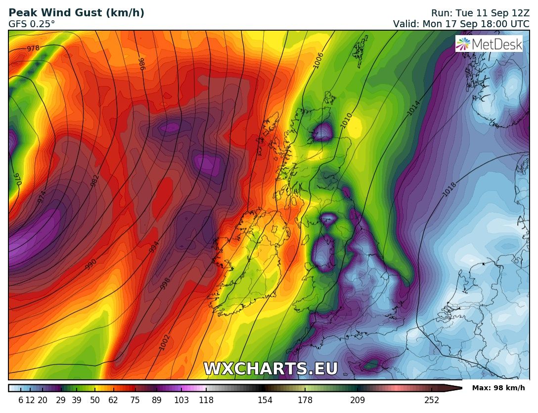
Winds on Saturday night into Sunday will also increase across Ireland and become moderate overland and strong around coastal areas and be south to southwesterly in direction. This can be seen on the chart below.
Next week there still is some uncertainty in the weather the outlook is for the weather to stay unsettled with the risk of a area oflow pressure moving close to Ireland or just of the west coast.
Current outlook for early next week is for windy weather but no storm. At this stage it would warrant a yellow weather warning but its to early to say yet as there will be further changes over the coming days with such a active Atlantic at the moment
Current outlook for early next week is for windy weather but no storm. At this stage it would warrant a yellow weather warning but its to early to say yet as there will be further changes over the coming days with such a active Atlantic at the moment
On the latest GFS mode run this afternoon we see the remnants of HURRICANE HELENE of the Coast of Africa and is currently a Category 2 Hurricane with maximum sustained wind speed of 95knts (110mph) (177kph) the hurricane is expected to move northwards over the next 24 hours and already peaked in intensity earlier this morning.
The cloud pattern has not changed much, and still consists of a large eye surrounded by deep convection. However, these convective tops have warmed a little, and consequently Dvorak numbers have remained steady. From now on, Helene will begin to move over increasingly cooler waters, and become embedded within higher shear in about a day. These environmental conditions should result in weakening, and the NHC forecast calls for a decrease in the winds at the same rate as the intensity consensus aids. Helene has turned toward the northwest or 310 degrees at 10 kt. Models continue to erode the ridge to the north of the cyclone, and are also developing a large mid-level trough over eastern Atlantic. This forecast flow pattern will force Helene to turn more toward the north-northwest and north ahead of the trough for the next 2 to 3 days. After that time, the cyclone will recurve in the mid- latitude westerlies, and will begin to lose tropical characteristics at the very long ranges. Track models are in very good agreement with this solution.
Current track of HURRICANE HELENE over the rest of this week and weekend
Current track of HURRICANE HELENE over the rest of this week and weekend
Over the next 48 hours HURRICANE HELENE will no longer be a hurricane and become a post tropical depression as it moves into the colder waters of the mid Atlantic. At the start of next week or around midweek this then low pressure may reach Ireland with stormy conditions or it may miss altogether. The latest GFS model for example has the remnants HELENE missing Ireland and passing over the southwest of England. There will be many changes over the coming days before any forecast can be giving and here at Donegal Weather Channel as I mentioned on this mornings forecast I would keep you updated when details become much clearer.
Below I have shown the latest model run from the GFS this evening shown the remnants HELENE over the southwest of the UK and of the south east of Ireland early next week.
remnants Hurricane HELENE of the southwest of the UK and of the south east of Ireland early next week.
remnants Hurricane HELENE of the southwest of the UK and of the south east of Ireland early next week.
I will update again in the coming days on early next week, and I would like to stress to people don’t get in a panic as there is no Hurricane hitting Ireland.or the UK.
Kenneth from the Donegal Weather Channel


