WEATHER BOMB - STORM WITH SEVERE WINDS ACROSS THE WEST, NORTHWEST AND NORTH LOOKING POSSIBLE ON FRIDAY MORNING
On Sunday Donegal Weather Channel issued a article regarding the risk of a potential strong and severe storm for the end of this week Friday. Models this morning continue to show a area of low pressure moving in from the Atlantic on Friday morning bringing the risk of very strong gale force winds and severe and damaging wind gusts on Friday morning. The exact track is not known as of yet but the main areas of concern are the west of Ireland, northwest of Ireland and northern areas of Ireland as well as Scotland.
You will notice in the headline I use the word “WEATHER BOMB” and the reason for this is due what the low does over the course of Thursday night and Friday. Some of the model runs including the Met Eireann high resolution model shows a pressure drop of more than 24 millibars in the space of 24 hours in a process known as explosive cyclogenesis or a weather bomb.
Rapid acceleration of air caused by the jet stream high up in the atmosphere can remove air from the column, reducing its weight so causing pressure to fall at sea level. This in turn sucks in air which converges from surrounding regions resulting in faster and faster rotation of the circulation, in the same way that ice skaters spin faster by drawing their arms in. The resulting winds peak over a period of a few hours and can be strong enough to bring down trees and cause structural damage.
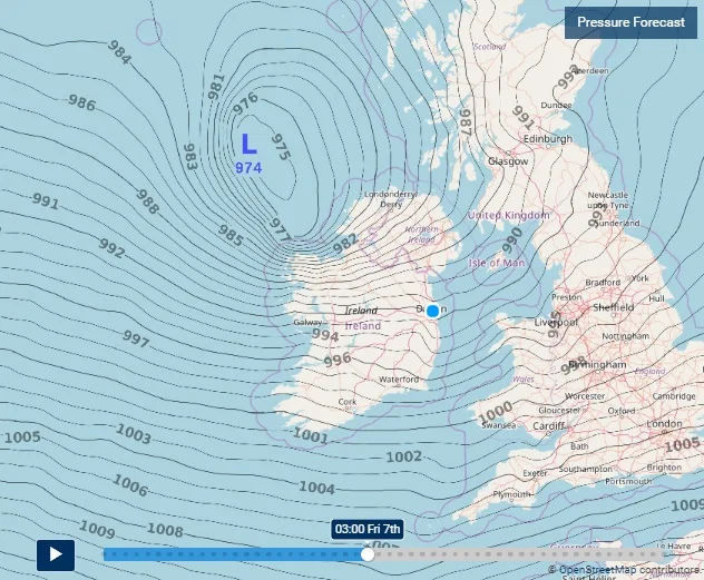
As the area of low pressure moves towards the west of Ireland the center of the low tracks of the northwest of Ireland and northeastwards over northern Scotland and as it does so it is raptly developing as it does so. Attached below this can be Seen on the latest Met Eireann pressure charts where the area of low pressure is at around 991hPa Thursday 18:00hrs and by the time it reaches northern Scotland the pressure has dropped as low as 967hPa by Friday 15:00hr which would be central pressure fall of 24 millibars in the space of around 21 hours. which would class it as explosive cyclogenesis.
Continues below
The latest GFS model, ECMWF model and GEFS model show this area of low passing closely to the west, northwest and north coast of Ireland. The latest model runs can be seen below. Some the other model suggest a massive drop in pressure within 24hr as the low rapidly develops.
With the present track of this areas of low pressure there will be a high risk of coastal damage and flooding going on the model runs this morning across western, northwestern and northern parts of Ireland with the county’s of Galway, Mayo, Sligo, Leitrim, Donegal and Derry worst effected. Strong winds, a large swell combined with a storm surge at high tide could lead to coastal flooding. One area of interest would be the Donegal bay area
swell chart for Ireland on Friday morning
JET STEAM
On the Chart below you will see the strong jet stream which will be over Ireland and the UK at the end of the week and on Friday morning the layer of winds on the Jet stream shown below is typically active at 20,000 feet to 50,000 above the surface and travel in what is known as the troposphere of Earth's multi-layered atmosphere. Below in the chart showing the Jet stream you can also see the area of low pressure which is been carried along and rapidly developing as approaches and moves away from the the west & northwest of Ireland and tracking towards Scotland
ECMWF MODEL MODEL
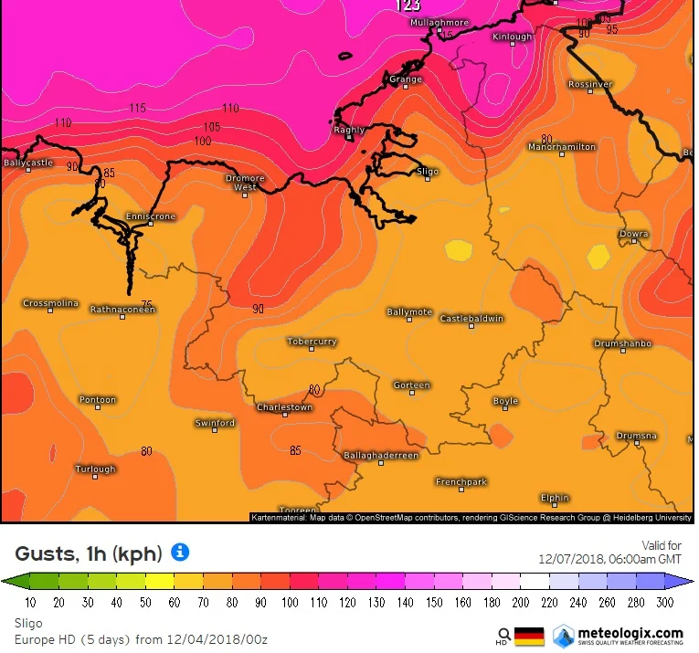
The latest model from the ECMWF model shows the possible gusts across Ireland on Friday morning and afternoon below I have attached these charts. you will find western, northwestern, and northern county’s predicted gust speed as these look likely to be the worst hit areas. Gust show in km/hr and some of the strongest gusts that show on these charts will most likely be over higher ground. At present gust of between 100km/hr to 130k/hr could be possible across western, northwestern and northern county’s especially coastal county’s. Gust of more than 130km/hr may occur over higher ground areas and mountains looking at the latest ECMWF model
IRELAND
Highest gusts shown on the chart will more likely to be recorded over higher ground and mountains
DONEGAL
Highest gusts shown on the chart will more likely to be recorded over higher ground and mountains
SLIGO & LEITRIM
Highest gusts shown on the chart will more likely to be recorded over higher ground and mountains
MAYO
Highest gusts shown on the chart will more likely to be recorded over higher ground and mountains
GALWAY
Highest gusts shown on the chart will more likely to be recorded over higher ground and mountains
NORTHERN IRELAND
A spell of rainfall also looks likely on Thursday night and Friday morning along with the risk of strong gale force winds and potentially severe and damaging gusts.
I will further updates later this evening when a little more detail can be giving on this potential spell of really active weather and possible storm at the end of the week
KENNETH MC DONAGH FROM THE DONEGAL WEATHER CHANNEL
Make sure to give this article a like on Facebook
2019 CALENDAR NOW ON SALE


