Monthly Long Range Forecast Update Ireland - 3rd May 2021
Photo between of a boat between Donegal town and Mullanasole, Donegal by Kenneth Mc Donagh Photography
This is the second issue of the Donegal Weather Channel Monthly Long range forecast issued every week looking up to a month ahead using data from the ECMWF and GFS models.
Please note that the longer range forecasts are more uncertain and will not always be right.
Extended Range Output
The output is rather different from the shorter period output of HRES and ENS products. It provides a more general overview of the forecast up to Day 46, focusing mainly on the week-to-week changes in the weather rather than attempting to give unsupportable detail on individual days. Output is mostly in the form of anomalies relative to ER-M-climate and is mainly shown as 7-day means for calendar weeks Monday-Sunday. Specialised products for the extended range also include information on potential tropical cyclone activity and the MJO during the coming month.
SPONSOR THE LONG RANGE FORECAST
If you have a business and would like to sponsor our weekly month long range forecast for a period of 1 week or 1 month please do contact Donegal Weather Channel at info@donegalweatherchannel.ie or message our Facebook page . Donegal Weather Channels service relies on sponsorship/advertising. Without sponsorship/advertising Donegal Weather Channel would not be able to give so many hours and a daily service.
The forecast will be issued by myself Kenneth and i will try to keep it simple making it easy for everyone to understand. If there is a term I use in the forecast which you may not know what it means I will explain what I am talking about .
Before I start with the long range forecast I will just explain what we will be looking at and how the forecast will work.
The forecast will be broken up into 4 section Example below :
Week 1 - Monday 3rd May 2021 -Monday 10th May 2021
Week 2 - Monday 10th May 2021 -Monday 17th May 2021
Week 3 - Monday 17th May 2021 -Monday 24th May 2021
Week 4 - Monday 24th May 2021 -Monday 31st May 2021
Things we will look at in the forecast:
Mean sea level pressure: Weekly mean anomalies
2m temperature: Weekly mean anomalies
Wind
Precipitation: Weekly mean anomalies (eg. rainfall and snowfall for a example.
Dust forecast ( Only in Week 1)
UV forecast outlook
Potential Pollen Levels
Forecaster - Kenneth Mc Donagh
Week 1 - Monday 3rd May 2021 -Monday 10th May 2021
Mean sea level pressure: Weekly mean anomalies
Lower pressure than average across Ireland this week ( Week1) will mean a lot more unsettled conditions across Ireland with weather fronts moving in of the Atlantic bring unseasonably wet and windy weather at the start of the week and again later this week into the weekend
Precipitation ( Rainfall): Weekly mean anomalies
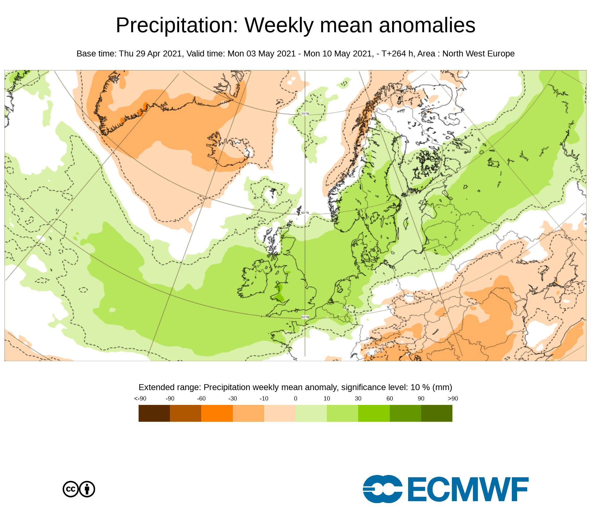
Rainfall amounts over week 1 will be above average between 10% to 50% above, Lowest rainfall amounts across the south of Ireland highest amounts across the northwest and north . An area of low pressure on Monday will bring heavy rainfall across Ireland and again later Friday into Saturday another area of low pressure looks set to move up from the southwest moving northwards across Ireland bring further heavy falls of rain. Further showers will occur over the week also and with much colder conditions than normal for the start of May some of these will fall as sleet and hail in places with the risk of some thunderstorm activity in places also.
The main risk of thunderstorms and hail will come on Tuesday & Wednesday with the northern half of Ireland most a risk. There are signals that further thundery showers may occur on Sunday.
Rainfall amounts between Monday 3rd may to Sunday 9th May 2021
Ulster - 60mm to 90mm ( Highest amounts in west Ulster)
Connacht - 50mm to 90mm ( Highest amounts in north & west Connacht)
Munster - 40 mm to 80mm (Highest amounts in south Munster)
Leinster - 50mm to 70mm (Highest amounts in south & east Leinster)
2m temperature: Weekly mean anomalies
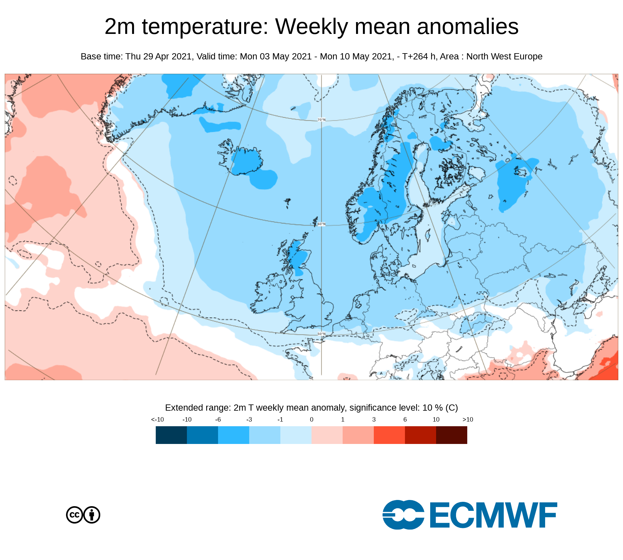
Temperatures over this week (week 1) will be below normal across Ireland between 2C to 3C below. There will be the risk of frost mid week on Tuesday night, Wednesday night and Thursday night with lows of between -3C to 2C . Overall day time temperatures will range between 8C to 12C up until Sunday the 9th of May.
Wind forecast
Some unseasonably strong winds strong winds on Bank holiday Monday as an area of low pressure passes across Ireland. Southwesterly winds, veering northerly through Monday will reach mean speeds of 50 to 65 km/h with gusts up to 100 km/h, particularly in coastal areas and on higher ground. There will be the risk of wave overtopping in coastal areas especially around high tide on Monday. Note will trees in full leaf this may lead to some trees or branches falling or snapping much easier.
Another area of low pressure is then forecast to pass close to Ireland over the later stages of Friday into Saturday bringing further windy conditions but winds at this stage do no look as strong as the earlier half of this week. Keep a eye on the daily National forecast section for updates on that .
UV forecast
Even with a cooler week than average for this time of year expected UV levels will be Moderate in any sunshine with the risk of sun burn possible.
Pollen Forecast
Pollen levels will be low to moderate over the week with pollen levels lowest during cloudy and wet weather and highest during any sunny dry periods. The main type of pollen will be tree this week.
Dust forecast
Dust levels will be low across Ireland during week 1.
Forecasters final note on week 1
Overall week 1 will be a rather unsettled week with the jet stream sitting across Ireland and is the reason for the wet and windy conditions to start this week with another low pressure system forecast to move close to Ireland later this week. The main hazards this week will be heavy rainfall leading to flooding and some heavy hail showers mid week leading to some temporary hail accumulations leading to slippery conditions. Farmers and Gardeners should be alert for the risk of frost mid week also with young plants and crops most at risk. The best of the sunshine will come Tuesday up until the early stages of Friday between any showers.
Week 2 - Monday 10th May 2021 -Monday 17th May 2021
Mean sea level pressure: Weekly mean anomalies
The latest outlook heading into week 2 is for average or just above average pressure to sit close to Ireland. Over the Atlantic there are signs that the Atlantic will become that bit weaker and have less of a influence on our weather which may allow higher pressure to build again over the week with a higher chance of nice sunshine. The week will see a west to northwest airflow.
Precipitation ( Rainfall): Weekly mean anomalies
Week 2 at this stage look set to be more settled across Ireland with below average rainfall amounts for much of Ireland but near normal across the northern half of the country. There are some signals that there may be showers to start the week with the risk if thunderstorms but becoming drier and sunnier over the midweek period of week 2
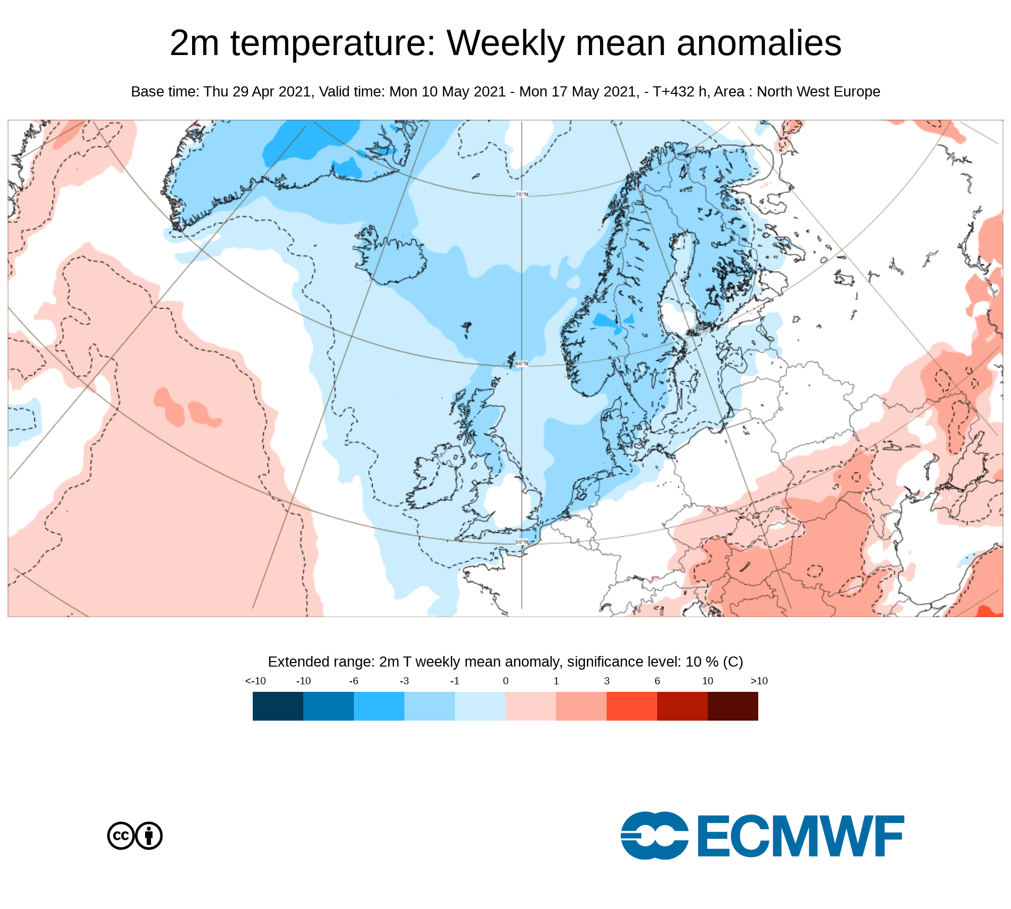
2m temperature: Weekly mean anomalies - Wind
Temperatures over week 2 will be near normal to just below average across Ireland with no signs of anything warmer at the moment. There again will be the risk of some frost overnight during the week but noting severe with the risk only slight in some areas. Overall day time temperatures will range between 8C to 13C up until Sunday the 16th of May.
Wind Forecast
With the current forecast outlook and higher chance of settled conditions there will be no risk of any strong winds during week 2.
UV forecast
Even with a cooler week than average for this time of year expected UV levels will be Moderate to high in any sunshine with the risk of sun burn possible.
Pollen Forecast
Pollen levels will be moderate to high over the week with pollen levels lowest during cloudy and wet weather and highest during any sunny dry periods. The main type of pollen will be tree this week.
Forecasters final note on week 2
For week 2 the outlook is for some heavy showers with the risk of thunderstorm activity early in the week but becoming drier and sunnier from midweek. The main hazards this week will be thunderstorms early on in the week. With calmer conditions this will lead to the risk of fog also forming during the week.
Week 3 - Monday 17th May 2021 -Monday 24th May 2021
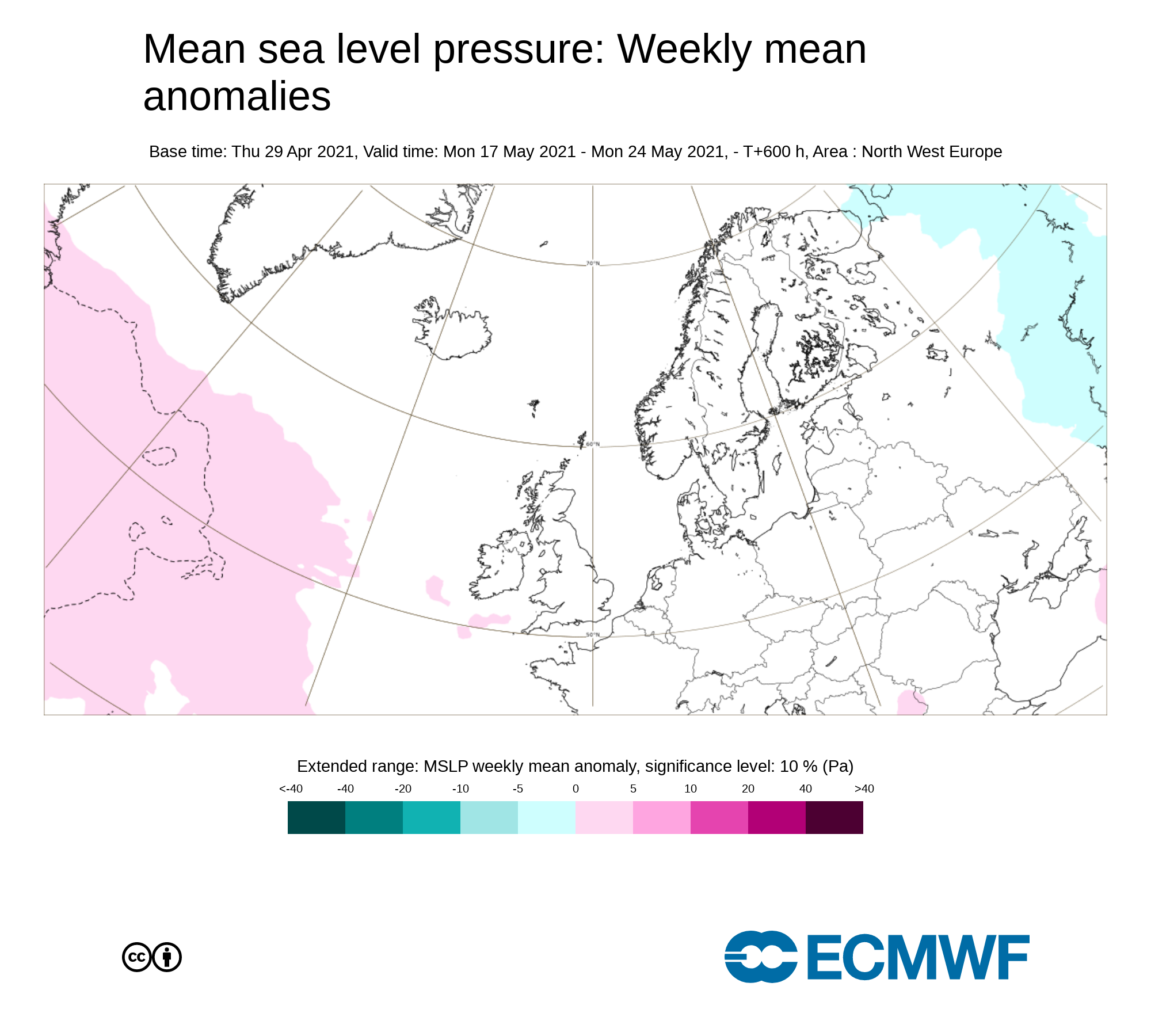
Mean sea level pressure: Weekly mean anomalies
The forecast for this period is a little more uncertain but the current signal is for near average to just above pressure to sit across Ireland on week 3. This will see mostly settled conditions but the week will see some rainfall. Week 3 will see a southwesterly to westerly airflow.
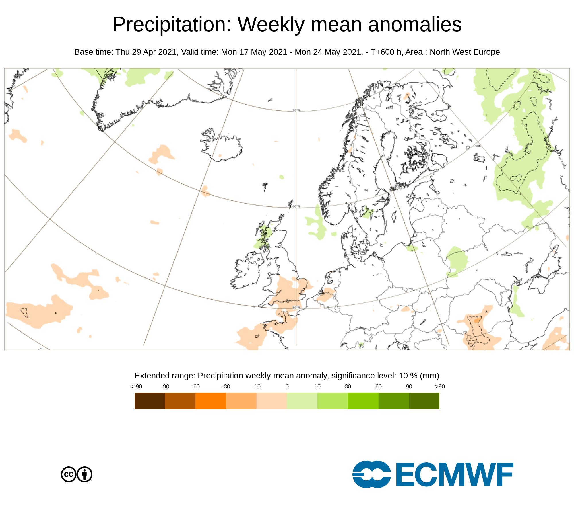
Precipitation ( Rainfall): Weekly mean anomalies
Over week 3 confidence in the forecast is that bit lower but the current signals from the ECMWF & GFS forecast models is for mostly settled conditions . At present rainfall amounts across the southern half of Ireland will be lower than average but near normal across the northern half of Ireland. Any rainfall this week will come in the way of showers.
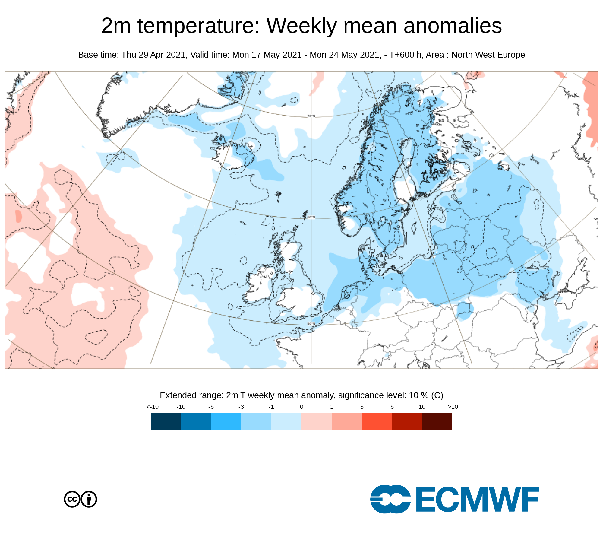
2m temperature: Weekly mean anomalies
Temperatures over week 3 will be near normal across Ireland. There will be less of a risk of frost with temperatures becoming that bit warmer into the mid to high teens by day possibly around 13C to 17C.
Wind forecast
Week 3 at the moment does not show any signs of windy conditions.
UV forecast
UV levels will be Moderate to High in any sunshine with the risk of sun burn possible.
Pollen forecast
Pollen levels will be moderate to high over the week with pollen levels lowest during cloudy and wet weather and highest during any sunny dry periods.. Grass pollen may start to rise this week.
Forecasters final note on week 3
Overall week 3 will be rather settled with high pressure still around. Any rainfall will come in the way of showers and at this stage the northern half of Ireland most at risk. There will be good sunny spells also over the week with near normal to above average sunshine amounts. At present no weather hazards look possible this week.
Week 4 - Monday 24th May 2021 -Monday 31st May 2021
Mean sea level pressure: Weekly mean anomalies
Confidence in this week is rather low and uncertain. There are some signals for low pressure across Ireland this week with unsettled weather conditions again with wet and potentially windy conditions
Precipitation ( Rainfall): Weekly mean anomalies
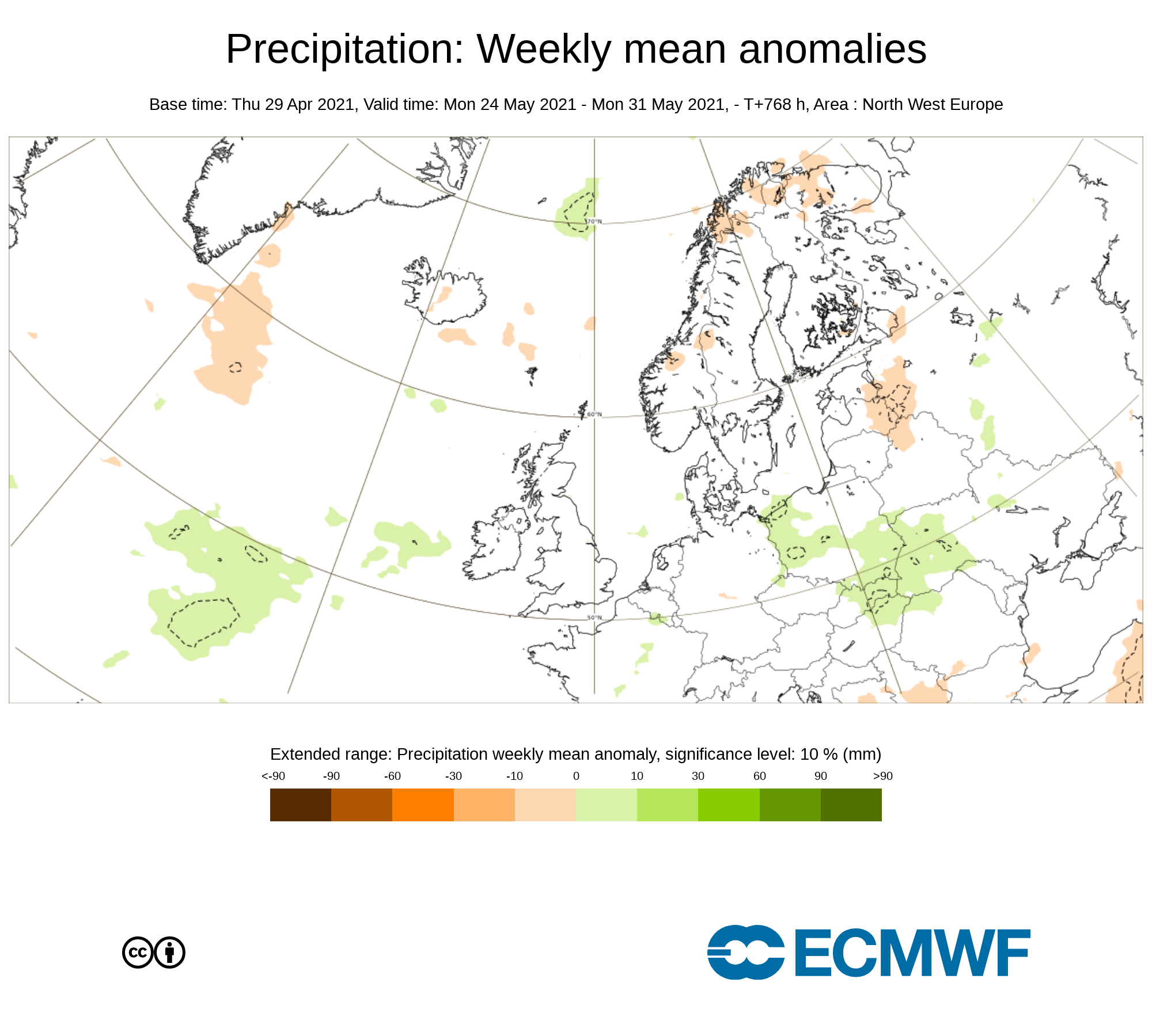
Again Confidence is rather low for this week but the latest signal is for above average rainfall amounts for week 4. The main amounts of rainfall this week look likely to come from areas of low pressure been swept in from the Atlantic as the jet stream sits close to Ireland steering them in of the Atlantic.
2m temperature: Weekly mean anomalies
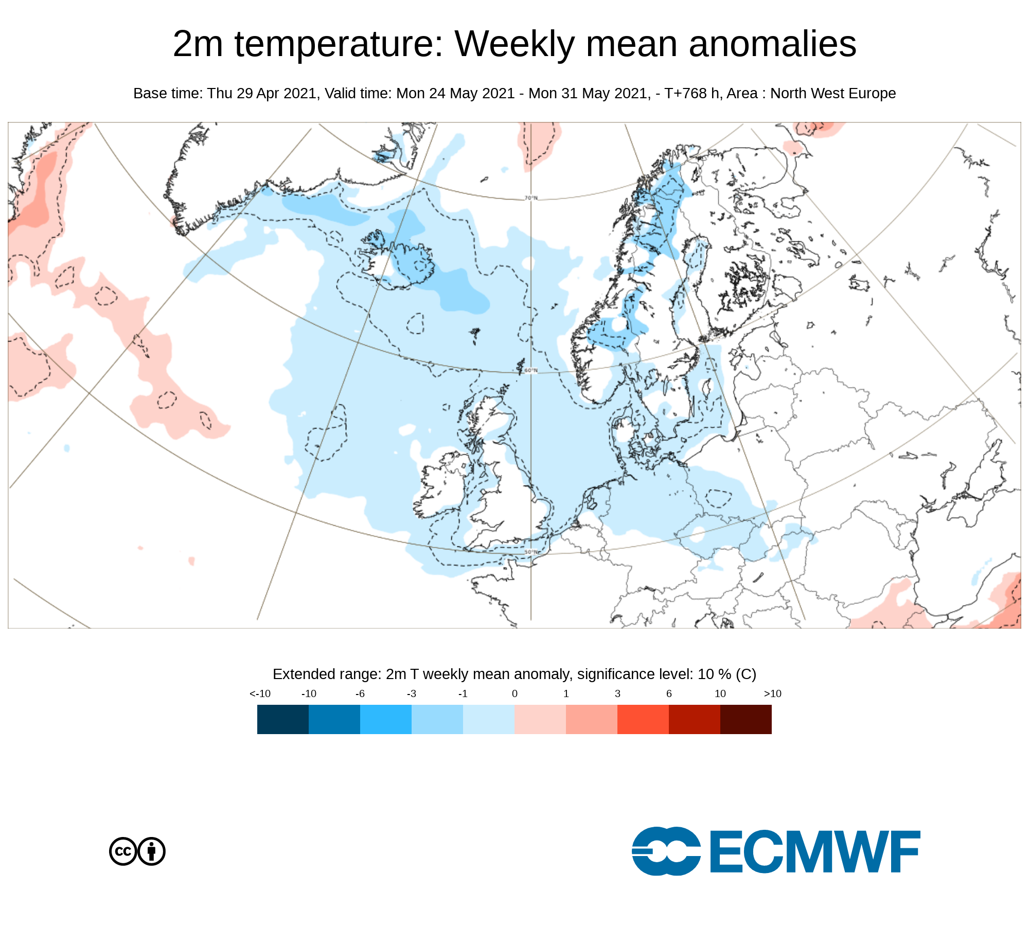
Again Confidence is rather low for this week but the latest signal is for Temperatures over week 4 been near normal across Ireland. Temperatures overall in the low to mid teens with no signs of any real good warm conditions
Wind forecast
There is a potential for some windy conditions this week with the lower than average pressure across Ireland. Some windy conditions may occur as areas of low pressure systems sweep in from the Atlantic.
UV forecast
UV levels will be Moderate to high in any sunshine with the risk of sun burn possible.
Pollen Forecast
Pollen levels will be low to moderate over the week with pollen levels lowest during cloudy and wet weather and highest during any sunny dry periods.. Grass pollen should start to rise this week.
Forecasters final note on week 3
With low confidence the latest signal for week 4 is for possible lower than average pressure with the higher risk of above normal rainfall amounts and windy conditions. Note that this is subject to change.
Sign up to our Newsletter

