
A Azores High pressure system looks set to build next week across Ireland bringing much warmer weather
Warmer weather signaled for later next week and weekend
A Azores high pressure system is been signaled on forecast models to build across Ireland over the second half of next week.
The Azores high is part of a belt of sub-tropical anticyclones in the northern hemisphere, other notable features from this belt include the Bermuda high and California high, and refers to an area over or close to the Azores Islands where there is relatively consistent high pressure and subsiding air over the Atlantic Ocean.
In summer the movement of the Azores high affects not only the Irish weather but also much of the UK & Europe, particularly during the mid-late summer when a ridge extending from the Azores can build north-eastwards across France and Germany.

The end of next week there are signals from both the European and American forecast models for a Azores High Pressure to push northwards into Ireland & the UK.
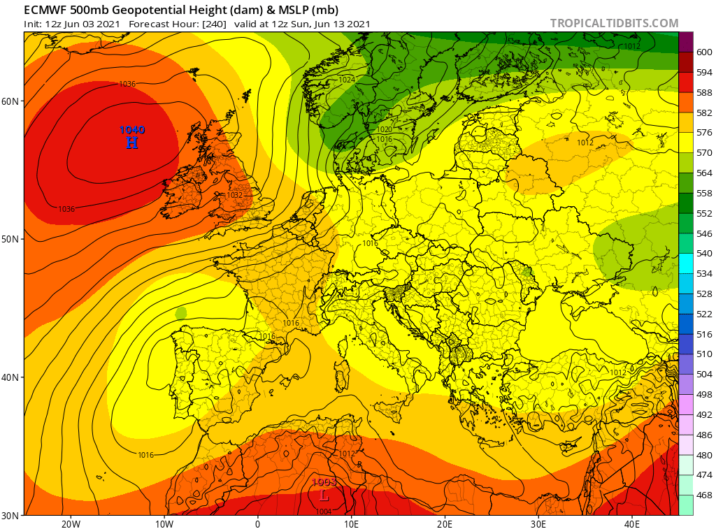
Looking at the latest 12z ECMWF (European) weather model run from this evening it shows the high pressure system moving northwards Wednesday, Thursday and Friday and strengthening over the course of the weekend with the high pressure system centered of the west and northwest of Ireland.
Another thing which is very interesting looking at the this evening ECMWF weather model the strength of the high pressure system with it suggesting it been around 1040hPa which is a rather strong high pressure system. The record for the highest pressure recorded in Ireland in June was at Clones in Monaghan back on the 14th of the month 1043.1 hPa.

Animation from this evening ECMWF model showing a Azores high pressure system moving northwards later next week

The GFS (American) weather forecast model is also showing signs of high pressure building from the Azores later next week with warmer weather also.
As for the temperatures later next week & next weekend it will all depend on if and where that high pressure system locates itself. We could see some places later next week in the high teens to low 20s and if the high locates itself in the right place possibly into the mid 20s next weekend. And if you get that heat it as you move into the following week there is then the potential for temperatures to rise into the high 20s across Ireland. I think for now the main focus will be on the end of next week and how the forecasts models model this high pressure system over the weekend but then we should have a fair idea of the possible outcome but the signs are positive to see many of the main forecast models indicate this in some way or form.
Donegal Weather Channel will have further updates over the weekend when things become that bit clearer
LATEST NEWS


