Heatwave on the way for Ireland at the end of this week lasting into the early days of next week
Ireland weather News
Its not a term we use very much in Ireland Heatwave because its something we don’t see very often but the term Heatwave in Ireland is only given when temperatures reach a certain figure or above for 5 or more days. So below we will describe what a heatwave actually is in Ireland.
Temperatures from Thursday to next Friday are expected to rise above 25C in Ireland with the days becoming warmer each day as we head into the weekend and early next week with some areas at risk of seen temperatures maxing out at around 27C to 29C.
In Ireland, the current definition of a heatwave is classified as five consecutive days with a maximum temperature in excess of 25°C. Heatwaves occur in summer when high pressure develops over the country. High pressure systems, also known as anticyclones, can be slow-moving and persist for a prolonged period of time, resulting in dry and settled weather. In anticyclones, strong subsidence, where cool air descends from aloft and diverges outwards at lower levels, leads to strong warming of the mid and lower levels of the atmosphere. The subsidence also supresses the formation of clouds and rain. When an anticyclone materialises over Ireland, the jet stream is usually located to the north of Ireland, keeping low pressure systems away.
Different air masses affect Ireland at different times of the year and this has a major impact upon the weather we experience in this country. The Tropical Continental air mass, which can originate over North Africa, is the least frequent air mass affecting Ireland and is most common in summer. Although the lower layers of this air mass are usually quite stable, unstable upper layers may give rise to severe thunderstorms. Its low humidity tends to bring us clear skies and long periods of sunshine. The highest temperatures experienced in Ireland usually occur under the influence of this air mass giving maximum temperatures in excess of 30°C.
Ireland only experiences occasional heat waves compared to other European countries. In August 1976, Birr, Co Offaly recorded heat wave conditions lasting 14 days (the maximum temperature recorded at that station during this event was 28.2°C (8.9°C above its Long Term Average (LTA))). More recently, heat wave conditions occurred in the summers of 2018, 2017, 2013, 2006, 2003, 1995, 1989 and 1983.
Droughts can be classified into four types, “meteorological (1–3 months), defined on the basis of rainfall deficiency; agricultural (1–6 months), when soil moisture is insufficient and results in a lack of crop growth and production; hydrological (6–24 months), when there is a lack of water in the hydrological system; and socio-economic, when the demand for water exceeds the supply” (Falzoi et al., 2019).
In Ireland there are three different meteorological drought classifications; A dry spell is a period of 15 or more consecutive days with daily precipitation of less than 1 mm. An absolute drought is a period of 15 or more consecutive days with daily precipitation less than 0.2 mm. A partial drought is a period of at least 29 consecutive days with a rainfall total averaging less than 0.2 mm of rain per day (Murphy, 2020).
During June and July 2018, Ireland experienced a prolonged spell of hot, sunny weather, associated with blocking high pressure conditions, which steered a weakened jet stream and Atlantic low pressure systems away to the North. The abnormally high temperatures and low rainfall amounts led to drought conditions. These conditions were also experienced in much of Northern and Western Europe
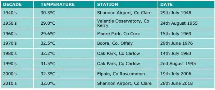
Highest maximum temperatures per decade since the 1940’s (Values prior to 1961 are limited to Synoptic stations, after 1961 the network increased to include climate stations)
Looking ahead to the end of this week high pressure builds across Ireland with each day becoming warmer as we head into the weekend. Temperatures look set to rise above 25C in parts of the country on each day between Thursday to next Tuesday next week with the peak of the warmest weather coming Saturday, Sunday, Monday and Tuesday with temperatures possibly rising as high as 28C and maybe even 29C in one or two places. No records are expected to be broken this weekend or early next week. Below you will find the Temperatures forecast from the latest GFS weather model from Thursday this week until next Tuesday. And the good news is that this evening ECMWF 18Z model run prolongs the heat and sunshine into the end of next week but at this range that cant be said that outcome will happen for certain.
A HEAT WAVE
A heat wave occurs where there are 5 consecutive days or more with maximum temperature over 25° C (that is, a daily maximum screen air temperature > 25° C).
A DRY SPELL
A dry spell is a period of 15 or more consecutive days with daily precipitation of less than 1.0mm (that is daily rainfall < 1.0mm).
A PARTIAL DROUGHT
A partial drought is a period of at least 29 consecutive days where the mean daily rainfall does not exceed 0.2mm (that is, a mean for period ≤ 0.2 mm per day).
AN ABSOLUTE DROUGHT
An absolute drought is a period of 15 or more consecutive days with daily precipitation of less than 0.2mm (that is, a daily rainfall tot


