
The northwest of the country at the risk of been impacted by very strong winds on Wednesday

The weather next week is set to turn very unsettled across Ireland with a very active and fast flowing jet stream set to start feeding low pressure systems near Ireland. With a strong Jetstream forecast this will also lead to a higher risk of a high impact storm effacing some parts of the country from around midweek next week. Earlier in the week we reported that a very strong wind storm is possible mid week next week and the last outlook from many of the weather forecast models till show this risk.
The latest GFS and ECMWF models show a strong wind storm moving close to the northwest and north of Ireland next week which could bring winds in excess of 110km/hr. At the moment based on the last charts this would also be a named storm.
At present it does look like the northwest of the country will see some very strong winds with a orange warning possible but this will become more clear over the coming 24hr to 48 hrs
See the image below which shows the very strong jet stream next week.

A strong jet stream across the Atlantic and over Ireland next week during the middle of the week

If next weeks low pressure is named it will be called storm Dudley. The main risk areas at present look set to be Connacht and Ulster with the west and north-western counites at the high risk of very strong and possibly damaging gusts. Latest ECMWF model can be seen below showing these very strong winds especially of the northwest of Ireland and to the west of Scotland with gusts in excess of 200km/hr at sea.
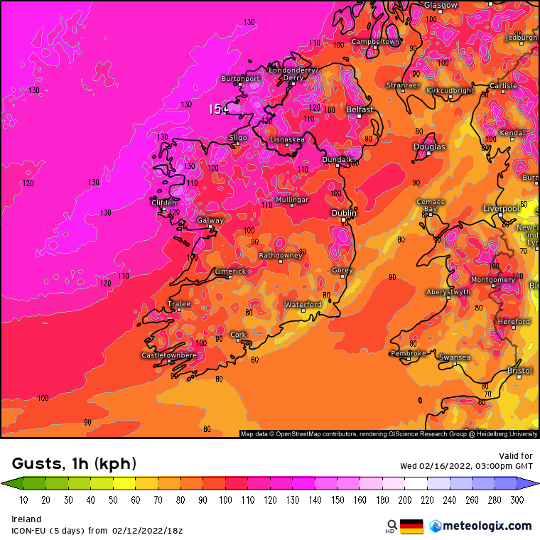
Strong wind midweek next week with the west , northwest and north most at risk
The biggest concern would be if this low pressure system was to track further south during the middle of next week and bring them stronger winds closer to Ireland. This is something which will have to closely watched over the coming day and weekend for any signals of this.

After midweek as we head into the end of next week and next week the outlook is for the weather to stay unsettled with the risk of further low pressure systems bring some wet and windy weather with the change also of another a named storm to follow for this period,
There are also some signals that there will be colder periods between these storm spells which may drag in some colder air bring some showers of hail sleet and snow at times.

If you have any outdoor plans from the middle of next week right through to next weekend be aware that it look set to be rather wet and windy with the risk of some possible wintry falls also in places

LATEST NEWS


