
POTENTIAL COLD SPELL UPDATE - Some changes to the forecasting models today

A good evening to everyone here is the latest update on the forecasting models for next week regarding any colder weather. There have been some change to the forecasting model in the last 24 hours with a very complex set up for next week.
The colder weather is still showing on the forecast model but noting over the top.
NOTE
Before I start I would ask any media websites or pages using our information to not use this for sensational headlines or stating that a beast from the east is on the way as there is no clear signs of this at all. We don’t mind any media outlets sharing or work as long as credit is giving and our words are not twisted.

Latest weather model outputs today (Wednesday 13th January 2021)
The 3 forecast models we will be looking at is the ECMWF, GFS, GEM
Below you can see the latest outputs from the 3 forecast models this evening
Charts attached show upper air temperatures at 850hPa which is the temperature at about 1.5 km which is generally above the atmospheric boundary layer. The 850 hPa temperature' is used to locate and identify warm fronts and cold fronts.
Todays forecasting models have showing a less colder start to next week but turning colder near the end of the week.
GFS
The latest GFS model attached below shows upper air temperatures above freezing for the Tuesday 19th & Wednesday the 20th of January 2021 as a area of low pressure sit across Ireland bring rain and windy weather across Much of Ireland and the UK
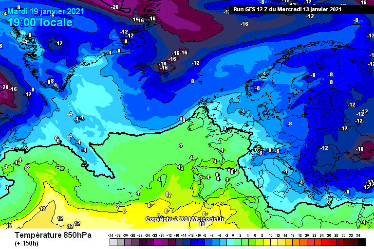
warmer upper air temperatures for the 19th and 20th of Jan 2021

Wet and windy weather expected for many Tuesday and Wednesday
As the area of low pressure clears to the east over mainland Europe on Wednesday into Thursday next week colder Arctic air is then dragged down from the north near the end of next week and over the next weekend. This can bee seen below on the animation attached

As the low clears over Europe eastwards colder air is then cirulated down from the north

ECMWF
The two model runs from the ECMWF today this mornings 00z run and this evenings 12z run are much the same however they are a little less colder looking than yesterdays runs. They still do show Ireland on the colder side of the Jet stream with warmer air to the north which means the chances of low pressure systems moving along the jet and up across Ireland into the colder air is possible. Below we will look at the start of next week looking at the forecast from the ECMWF model.

Warmer upper air temperatures on Tuesday 19th Jan 2021 across Ireland but this changes by Wednesday dur to a area of low pressure dragging down colder air from the north as it clears to the east across mainland Europe

As the area of low pressure clears to the east across Europe then on Wednesday the 20th of Jan 2021 colder air is dragged down from the north
So Tuesday looks set to start of Mild with rain on the ECMWF as a developing low clears eastwards overnight Tuesday and Wednesday next week and as it clears to the east on Wednesday it then pulls down colder air from the north turning rain across Ireland and the UK to sleet and snow which can be seen on the animation below with the sleet and snow showing as purple pink colour

Now below we will look at the warmer air mass at first when the low move across Ireland and how it become colder as the low clear to the east on Wednesday

GEM
The Gem model is a little different from the ECMWF and GFS with a split of colder air over the northern half of Ireland and warmer air across the south of Ireland. It is also not really going for the idea of a low pressure system moving across Ireland next Tuesday into Wednesday but for me personally I would with the ECMWF and GFS model outlook.

Many will remember the famous 2010 cold spell in latter part of November that year when northern blocking established over Greenland which resulted in the Jet Stream moving south, allowing cold air to flow in from the north and east.
Snowfall
Still at this stage forecasting snow is yet to early for next week but out of the models runs today the ECMWF model run looks best for snowfall during the middle of next week and shows what i have mentioned in my previous post what could happen if we have milder air just to the south of Ireland and colder air sitting over us with a are of low pressure moving over the country moving into the cold sector and rain turning to sleet and snow. It will be the start of weekend before we have any real idea on the outcome for middle of next week and the end of this weekend before we know what is ahead for the end of next week and the following weekend. But above gives you some what of a idea of what to expect early next week.
Extended range - Weekly mean anomalies
The 2m temperature: Weekly mean anomalies Extended range - Weekly mean anomalies from the ECMWF from Monday the 18th of January until Monday the 25th of January shows the weekly mean temperatures anomalies between -1C to -2C below average

2m temperature: Weekly mean anomalies. Extended range - Weekly mean anomalies
POSSIBLE OUTCOME NEXT WEEK
To start the week Monday 18th & Tuesday 19th Milder 4C to 8C. A area of low pressure then possibly moving across Ireland on Tuesday giving wet and windy weather but as it clears to the east across mainland Europe it then pulls down colder air from the north (Arctic air) with the increasing risk of some wintry falls of rain, sleet and snow with higher ground areas at the highest risk.
Towards the end of next week and over the next weekend remaining cold but not significant cold weather is expected. No beast from the east again I say no beast from the east. Some of the models including the long range forecast from the ECMWF and GFS shows it could turn a little more cold but at this stage its hard to know.
Anyone posting charts telling you its going to snow for any day next week at this stage are just fooling themselves as I mentioned in my update last night its way to far out and we can only look at snowfall at around 1 to 3 day out before really forecasting a outcome due to the amount of parameters which have to fall into place.
If you liked this update make sure to give it a like and let us know what you think in the comments
Regards Kenneth
You can find all the latest weather warnings and forecasts by downloading our app from the google play store by clicking below

LATEST NEWS


