
Storm Eunice update - Severe and damaging winds along with heavy snowfall expected Friday morning
Storm Eunice set to bring disruptive weather to Ireland
Storm Eunice which will effect Ireland on Friday morning and afternoon and will bring some disruptive weather with severe and damaging winds expected across the southern and western half of Ireland and possible heavy snowfall across western and northern areas particularly the northwest.
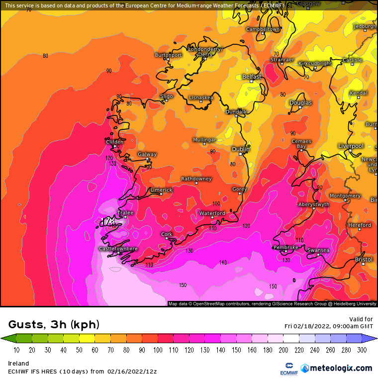
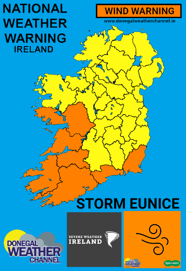
This afternoon Met Éireann issued the first warnings for storm Eunice following yesterdays early weather Advisory. The warning issued was for 3 weather element Wind, Rain and snow. This warning is a early warning and was followed by a Orange wind warning for Galway, Clare, Limerick, Kerry, Cork ,Waterford and Wexford for severe and damaging gusts of up to 130km/hr for Friday morning. There is a potential for further upgraded warnings for these areas over the coming hours once the track of Storm Eunice is more certain.

STRONGEST WINDS IN THE SOUTHWEST, SOUTH AND SOUTHEAST
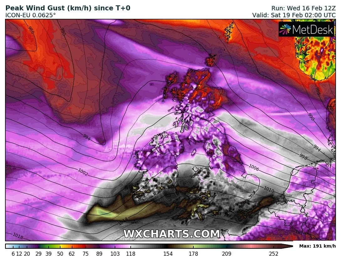
Storm Eunice will be a fast moving cyclone and will also be a storm that only starts to develop later Thursday morning southwest of Ireland and north of the Azores it will quickly advance west to east towards Ireland with the center of the storm set to pass close to Munster and south Leinster which is been steered along by a very intense and fast moving jet stream with Storm Eunice developing into a serious windstorm over the early hours of Friday morning less than 24hours before it even existed. Storm Eunice will bring strong and severe gusts to many parts of Ireland but the main concern is when it reaches the southwest of Ireland it could produce gusts along coastal area there of up to 170km/hr particularly across coastal areas of Clare, Kerry and Cork with damaging winds also across Limerick and Wexford of up to 130km/hr. There is also a chance more counties in the southeast and east will be added to this orange wind warning in the coming hours especially Wicklow and Dublin.
Some disruption is expected along with a possibility of coastal flooding.
There is another added risk of a feature called a Sting Jet. With Storm Eunice in particular the risk of one of these developing is high . A sting jet is a small area of very intense winds (often 160km/hr (100mph) or more) that can sometimes form in powerful weather systems crossing Ireland and the UK. Relative to the size of the storm, the sting jet is narrow, often 50 kilometres or 30 miles across, and only lasts 3 to 4 hours.
Elsewhere there will also be strong winds across the rest of Ireland from storm Eunice with mean speeds of 50 – 65km/h with damaging gusts of 80 – 110km/h, stronger on exposed coasts and on high ground. Some disruption is expected along with a possibility of coastal flooding.
If the weather models take storm Eunices track a little further southwards this would keep the worst of the winds offshore.
We are expecting wind warning updates tomorrow morning to follow from Met Éireann.

SNOWFALL RISK FOR THE WEST, NORTHWEST AND NORTH
The other hazard includes snowfall on the northern flank of storm Eunice on Friday morning as colder air is drawn in across the west and north of the country with heavy precipitation transitioning from rain to falls of heavy snowfall giving accumulations especially across parts of Connacht, Ulster and the North Midlands. This may start as rain and sleet and turn rapidly to snow. The latest track on the ECMWF model and GFS model shows some disruption across western and northern areas on Friday morning with some lowland areas possibly seen 5cm of snow and even as much as 15cm with upland and mountainous areas seen some significant falls of snow between 10cm to 30cm. The freezing level is expected to be around 150MASL for some which is Meters Above Sea Level.
With some strong winds across Connacht and Ulster there will be the added risk of blizzard conditions locally and blowing snow.
Again if storm Eunice was to track a little further south this would bring the snowfall risk to areas further south also. If it was to track further south then it could also mean less of risk of snowfall and stronger winds to the south. So for now its a wait to see what sort of model run outputs we see over the coming hours as we get closer to the time.
The National Directorate for Fire and Emergency Management (NDFEM) crisis managemet team held a second virtual meeting today with Met Eireann, the Office of Public Works (OPW), local authorities, the principal response agencies, and key departments. Another meeting is planned for noon tomorrow. Met Éireann who have been updating them daily on the scenarios and it was mentioned that a orange level snow/ice warning may be issued on Thursday morning ahead of Friday morning. Local authorities are on standby.
Just to add on to the snowfall update another front is expected to move across Ireland on Saturday morning bringing the risk of further snowfall for places before turning back to rain again but details on this are still very uncertain


HEAVY RAINFALL AND FLOODING
There will be another added risk of flooding due to heavy rainfall with some rivers already running high and some in the northwest of Ireland bursting there banks last night so with more rain, sleet and snow added to that over the coming hours and this weekend this risk will grow larger by day.

Rainfall totals between Wednesday evening and Sunday night
Make sure to stay tuned to the last forecast over the coming hours and week for all the latest
Kenneth from the Donegal Weather Channel

LATEST NEWS


