
Storm Eunice update - Storm Eunice is just southwest of Ireland and will soon hit

Storm Eunice set to bring disruptive weather to Ireland
Storm Eunice which will effect Ireland in the coming hours and will bring some disruptive weather with severe and damaging winds expected across the southern and western half of Ireland and possible heavy snowfall across western and northern areas particularly the northwest.
There are now multiple warning in place across Ireland for different weather types with the most damaging winds expected across the southern half of Ireland.
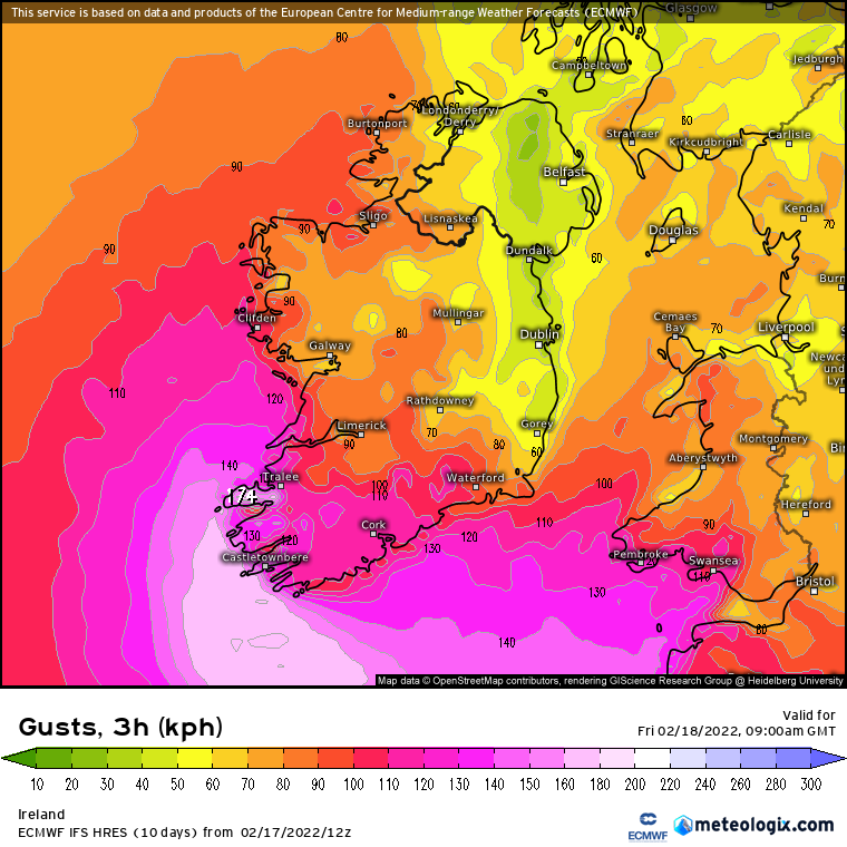
A Red wind warning is in places for Cork, Kerry, Clare and Waterford. Storm Eunice will track quickly over Ireland tonight and Friday morning bringing severe and damaging winds. Southwest winds veering northwest will reach mean speeds in excess of 80 km/h with gusts in excess of 130 km/h. Some coastal flooding, especially at high tide.

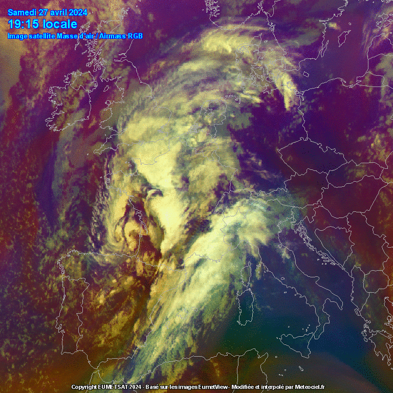
Storm Eunice can be seen to the southwest of Ireland tonight of shower with some of the outer rain bands arriving into the south and west of the country.
Track storm Eunice below
Storm Eunice will bring strong and severe gusts to many parts of Ireland but the main concern is when it reaches the southwest of Ireland on Friday morning it could produce gusts along coastal area there of up to 170km/hr particularly across coastal areas of Clare, Kerry and Cork. Such winds would be destructive.

SNOWFALL RISK FOR THE WEST, NORTHWEST AND NORTH
The other hazard includes snowfall on the northern flank of storm Eunice tomorrow morning as colder air is drawn in across the west and north of the country with heavy precipitation transitioning from rain to falls of heavy snowfall giving accumulations especially across parts of Connacht and Ulster. Forecasting models show good amounts with disruption across western and northern areas on Friday morning with some lowland areas possibly seen 3cm to 8cm of snow with upland and mountainous areas seen some significant falls of snow between 10cm to 30cm.
With some strong winds across Connacht and Ulster there will be the added risk of blizzard conditions locally and blowing snow.
Heavy wintry showers of sleet and snow will continue into the afternoon

We can expect to see fallen trees, damage to power lines and buildings, with hazardous driving conditions and delays and cancellations to transport.
HEAVY RAINFALL AND FLOODING
There will be another added risk of flooding due to heavy rainfall with some rivers already running high and some in the northwest of Ireland bursting there banks last night so with more rain, sleet and snow added to that over the coming hours and this weekend this risk will grow larger by day.
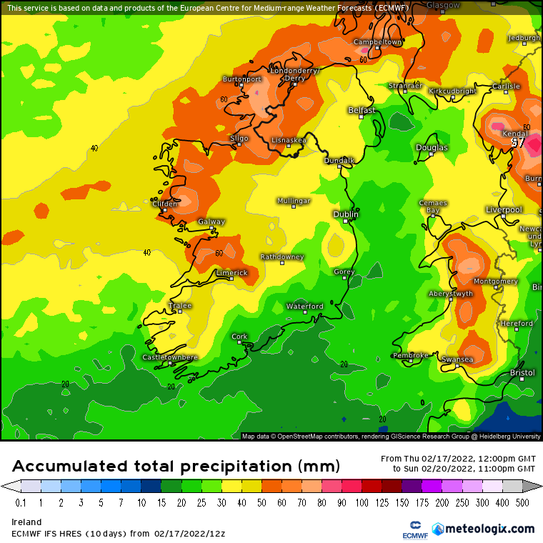
Rainfall totals between Wednesday evening and Sunday night
NATIONAL WEATHER WARNING
🔴STATUS RED - WIND WARNING FOR CORK, KERRY AND CLARE🔴
Storm Eunice will track quickly over Ireland tonight and Friday morning bringing severe and damaging winds. Southwest winds veering northwest will reach mean speeds in excess of 80 km/h with gusts in excess of 130 km/h. Some coastal flooding, especially at high tide.
Issued: 16:34 Thursday 17/02/2022
Valid from: 03:00 Friday 18/02/2022 to 08:00 Friday 18/02/2022
🔴STATUS RED - WIND WARNING FOR WATERFORD🔴
Storm Eunice will track quickly over Ireland tonight and Friday morning bringing severe and damaging winds. Southwest winds veering northwest will reach mean speeds in excess of 80 km/h with gusts in excess of 130 km/h. Some coastal flooding, especially at high tide.
Issued: 16:37 Thursday 17/02/2022
Valid from: 07:00 Friday 18/02/2022 to 11:00 Friday 18/02/2022
🟠STATUS ORANGE - WIND WARNING FOR CARLOW, DUBLIN, KILDARE, KILKENNY, LAOIS, OFFALY, WEXFORD, WICKLOW, MUNSTER, GALWAY🟠
Storm Eunice will track quickly over Ireland tonight and Friday morning bringing severe and damaging winds for a time. Southwest or cyclonic winds becoming northwest will reach mean speeds of 65 to 80 km/h with gusts up to 130 km/h. Some coastal flooding, especially at high tide.
Issued: 09:36 Thursday 17/02/2022
Valid from: 03:00 Friday 18/02/2022 to 11:00 Friday 18/02/2022
🟠STATUS ORANGE - SNOW WARNING FOR DONEGAL, LEITRIM, SLIGO, MAYO, ROSCOMMON🟠
Storm Eunice will bring heavy sleet and snow leading to blizzard-like conditions in parts with treacherous driving conditions.
Issued: 10:36 Thursday 17/02/2022
Valid from: 03:00 Friday 18/02/2022 to 15:00 Friday 18/02/2022
🟡STATUS YELLOW - WIND & RAIN & SNOW WARNING FOR IRELAND🟡
Storm Eunice will track over Ireland on Thursday night and on Friday bringing very strong winds and falls of heavy rain, sleet and snow. Some disruption is likely along with a possibility of coastal and spot flooding. Warnings will be updated on Thursday morning.
Issued: 10:49 Wednesday 16/02/2022
Valid from: 01:00 Friday 18/02/2022 to 15:00 Friday 18/02/2022
CLICK HERE OR THE WARNING MAP BELOW TO VIEW LATEST WEATHER WARNINGS

Make sure to stay tuned to the last forecast over the coming hours and week for all the latest
Kenneth from the Donegal Weather Channel

LATEST NEWS


