
Weekend storm update - Strong winds, heavy rainfall and thunderstorms for parts of Ireland

Strong winds across parts of the country on Friday night and Saturday morning
At the end of this week and over weekend we will see the north Atlantic jet stream become alive with a area of low pressure in the Atlantic engaging with the jet stream and rapidly deepen over the course of Friday which is when the pressure falls.
The image overlay below on the chart shows the Jetstream on Friday night with the area of low pressure marked as a L just to the west of Ireland been carried along the jet just of to the northwest of Ireland.

The jet stream next week strengthening over the weekend and next week with areas of low pressure rolling along the jet
This low will bring wet and windy weather across Ireland Friday night and Saturday morning

CURRENT WARNINGS
At midday Thursday weather warnings where issued for a number of counites along coastal areas for wind and rainfall
A status yellow rain warning has been issued for Galway and Mayo valid from 9pm Friday 23rd Oct to 9am on Saturday 24th Oct.
2 yellow wind warnings have been issued with different validity times:
A status yellow wind warning has been issued for Donegal, Galway, Mayo, Clare and Kerry valid from 10pm Friday 23rd Oct to 7am Saturday 24th Oct.
A status yellow wind warning has also been issued for Cork, Waterford and Wexford valid from midnight to 11am on Saturday 24th Oct.
These warnings will be reviewed over the next 24 hours and any updates will be issued as required.
As the Atlantic low passes between Ireland and Iceland it will see bands of rainfall sweep west to east across Ireland on Friday night and Saturday morning with very heavy falls in places with the risk of thunder which will lead to some spot or localised flooding along with the risk of river flooding especially due to how saturated the ground is at present with all the rain so far this week. There could be a further 20mm to 40mm of rainfall across some southwestern, western and northwestern counties practically across Donegal, Mayo, Galway and Kerry where the highest amounts look set to fall at present further updates to the warnings may be added tomorrow morning or afternoon.


The latest model runs from the ECMWF this Thursday night or borderline for this low pressure system needing to be named. Note a Orange wind warning would need to be issued for the storm to be named.
On Friday night southwest winds will strengthen across Atlantic coastal counties and become gusty to strong winds gusting between 90 and 110km/h (Donegal, Mayo, Galway, Clare, Limerick and Kerry
Stronger winds may occur across Donegal, Mayo, Galway and Kerry for a time on Friday night and early Saturday morning with winds gusting between 100 and 120km/h. A Orange warning may be issued for strong winds but at present this warning would be under the lower end of the scale for a Orange warning. Strongest winds in these areas will be across exposed coastal parts and over high ground so a orange warning may not be required but if there any shifts or change with the storm on model Friday morning warnings will be updated.
Strong wind combined with high tides could also lead to some coastal or tidal flooding in places with sea walls been over toppled.
Southwesterly winds will ease for many areas on Saturday afternoon and evening and become gusty, however across Atlantic coastal counties winds will remain strong especially across coastal areas.
THUNDERSTORM & HAIL RISK
The band of heavy rainfall will move west to east across Ireland on Saturday morning but clear to the east by midday with heavy showers following for the afternoon which could produce hail and thunderstorms.
These showers will be heaviest across west Ulster, west Connacht and west Munster where there will be the risk intense downpours at times with thunder and hail. Away from these areas there will be much drier weather with good sunny spells these best across the east.
The below chart shows the potential CAPE on Saturday across Ireland. CAPE actually stands for (Convective Available Potential Energy, and it is a useful tool for determining the severe weather potential at a given location at a given time.
CAPE is a measure of how much energy an air parcel would gain by being raised to a specific height in the atmosphere. The more potential energy an air parcel possesses, the greater the odds that that parcel can be lifted high enough in the atmosphere to produce convective weather systems, such as thunderstorms and tornadoes.
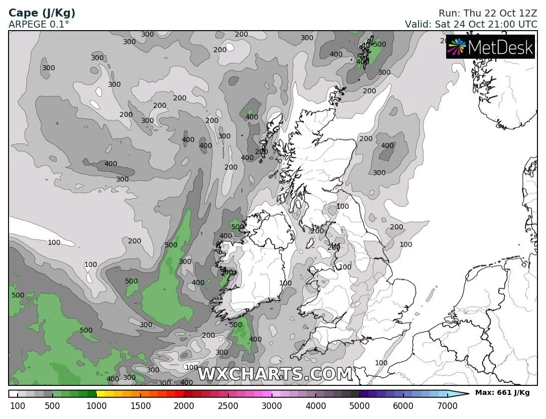
CAPE chart showing a higher risk of thunderstorms across Atlantic coastal counties
A RISK OF A VERY STRONG ATLANTIC LOW NEXT WEEK THE REMANATS OF HURRICANE EPSILON
At present in the tropical Atlantic we have Hurricane Epsilon which rapidly intensify this afternoon and is now a category 3 hurricane on the Saffir-Simpson Hurricane Wind Scale. Hurricane Epsilon was located about 200 miles (325 km) east of Bermuda. Epsilon is moving toward the north-northwest near 9 mph (15 km/h).

Hurricane Epsilon will have to be carefully watched over the coming days as these hurricanes can spring up surprises more than often. Epsilon was not expected to become a major hurricane but has now and is now a CAT 3 hurricane.
Once the Hurricane engages with the Jetstream early next week is losses its Hurricane characteristics and goes through extra-tropical transition and at that stage is will become a Atlantic low but it will nearly triple in size and become a massive Atlantic storm with a large wind field as can be seen on the images below which shows Epsilon at present and early next week
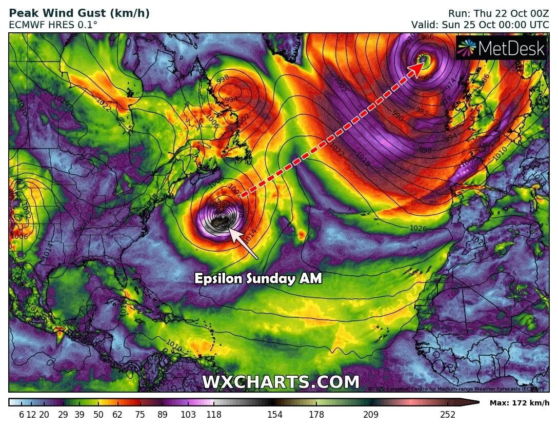

Hurricane Epsilon will bring the risk of strong winds, heavy rain, very high seas and coastal flooding next week but the actual impacts it will have cant be said for certain as of yet.
Possible time frame and effects Ireland may feel from this powerful low will be Tuesday night the 27th October and Wednesday 28th October 28th .
I will have further updates over the end of this week and this weekend on the two storm risks with the first storm on Saturday and then next week around Tuesday possibly into Wednesday.
Kenneth Mc Donagh from the Donegal Weather Channel
You can find all the latest weather warnings and forecasts by downloading our app from the google play store by clicking below

LATEST NEWS


