STORM ASHLEY UPDATES - IRELAND
STORM ASHLEY LIVE UPDATES
FOLLOW BELOW FOR LIVE UPDATES ON STORM ASHLEY
STORM ASHLEY INFORMATION
Storm Ashley has been named by the Met Office UK and a status orange weather warning has been issued for Donegal, Sligo, Leitrim Clare, Kerry, Galway, Mayo, Fermanagh, Tyrone, Derry & Antrim for winds gusting between 110km/hr to 130km/hr with the risk damaging gusts expected throughout Sunday afternoon & evening.
Worst effected counties will be western and northwestern counties with further updated and upgraded warning possible over the next coming hours.
A red level warning is not likely however a red marine warning around coastal parts of the west and northwest can't be ruled out.
Across the rest of Ireland winds will also be strong with winds gusting between 90km/hr to 110km/hr
There will be a lot of debris due to many leafs still on trees at the moment. There will be a risk of trees coming down much easier then a storm during winter, leafs on trees act as a sail this time of year and are more prone to come down.
Power outages will occur in many areas on Sunday as the storm passes of the west and northwest of Ireland. Power outages will be most common along western, northwestern and northern counties.
Coastal flooding and damage may occur along western and northwestern counties due to exceptionally high astronomical tides combined with strong winds and a storm surge of up to 1 meter possible.
The public should avoid exposed beaches, cliffs and piers, harbour walls and promenades along the coast during storm conditions on Sunday morning up until Monday morning and not put your life at risk as well as others at risk.
A period of strong winds are also expected Saturday night with the strongest wind in the south potentially occurring then.
Anyone planing to travel by air or sea on Sunday morning, afternoon and evening there is likely to be some disruption and it would be important to check in before travelling .
LIVE UPDATES WILL APPEAR UNDER HERE OVER THE COMING HOURS
STORM ASHLEY UPDATE 21/10/2024 - 09:27HRS
Around 16,000 homes and businesses are still without this morning with Mayo, Galway and Kerry some of the worst affected areas. The ESB has done massive work in the passed 24 hours to restore around 37,000 homes and businesses last night.
A spokesperson for Donegal County Council said trees fell in quite a number of locations such as Ardara, Crolly, Gaoth Dobhair, Fánaid, Kilmacrennan, Milford, Rathmullan, Castlefinn, Raphoe, Lifford, Malin Head and Greencastle.
Thankfully no major flooding was observed last night at high tide.
STORM ASHLEY UPDATE 20/10/2024 - 18:21HRS
ESB Networks says 53,000 homes and businesses are without power this evening the worst impacted areas for power cuts include Mayo, Galway, Sligo, Clare and Kerry, as well as north Cork and north Dublin.
Around 20,000 homes in Northern Ireland are without power.
STORM ASHLEY UPDATE 16:34HRS - concerns around high tide this evening
Closely watching things this evening across the southwestern, western and northwestern coasts as a storm surge and exceptionally high tide is expected with a big risk of coastal flooding. It's highly advised that the public stay away from coastal waters and follow the advice of local authorities. A wave of 18.5 meters was measured of the southwest of Ireland in the past hour so this is a concern around high tide which will be around 8pm.
STORM ASHLEY UPDATE 15:33hrs - 20/10/24
Donegal - Emergency services are currently at the scene of a serious road traffic collision in eastern Donegal between Ballybofey and the crossroads village. Local diversion are in place.
STORM ASHLEY UPDATE 15:01hrs - 20/10/24
🔴Conditions along west Galway and west Mayo should be treated like a red warning. Reports of a lot of damage there at the moment. Winds have exceeded the orange warning criteria for 2 hours in a row. West Donegal (coastal areas) should prepare for similar wind speed later his afternoon and evening
STORM ASHLEY UPDATE 14:30hrs - 20/10/24
STORM ASHLEY UPDATE WINDS CONTINUE TO INCREASE WITH WIDESPREAD POWER OUTAGES
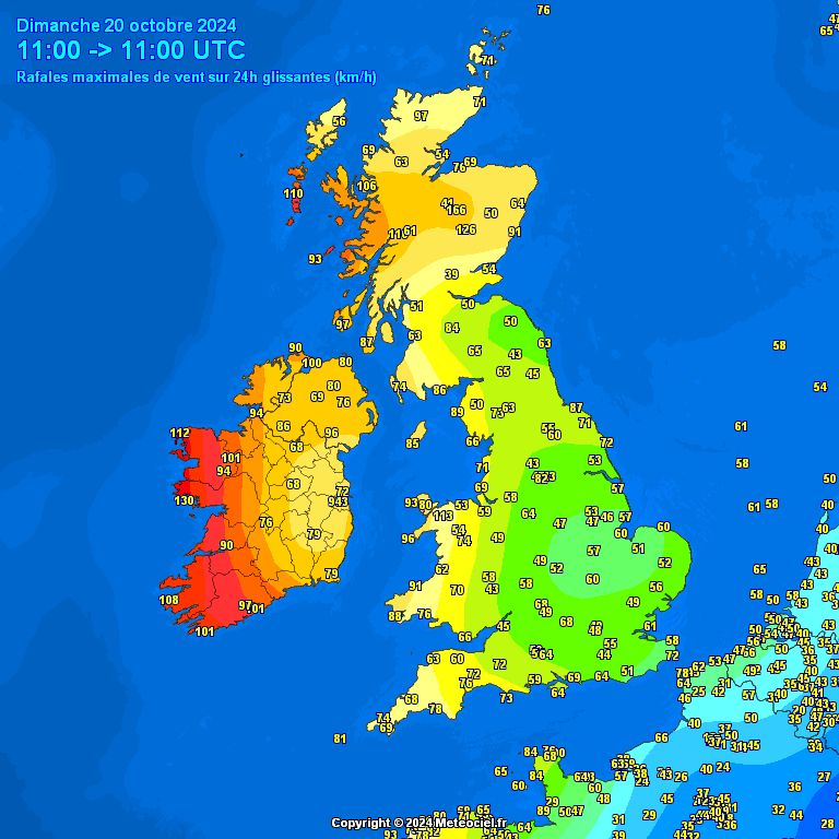
Winds continue to increase this afternoon with a gust of 137km/hr recorded at Mace Head, Galway, 133km/hr at Belmullet, Mayo and 124km/hr at Newport, Mayo.
There is also widespread power outages across the country with thousands with no power at the moment.
Winds have also now started to increase across the northwest and north and will continue to over the afternoon and evening.
STORM ASHLEY UPDATE 12:55hrs - 20/10/24
A Tree has bewn reported down in Lifford, Donegal this afternoon due to strong winds.
Thanks to Aine Doherty for the report.
STORM ASHLEY UPDATE 12:42hrs - 20/10/24
Winds really starting to ramp up now with a gust of 148km/hr recorded in Clew Bay, Mayo. A gust of 130km/hr also measured at Mace Head, Galway.
For the northwest and north in the next hour winds will really start to strengthen also so take care if you are out and about today.
STORM ASHLEY UPDATE 11:00hrs - 20/10/24
A good rise in wind speeds now along the west with gust of up to 108 at Mace Head, Galway and Belmullet, Mayo. There has also been a gust of 134km/hr recorded in Clew Bay, Mayo in the past hour.
🟠Orange warnings are now in place for Donegal, Sligo, Leitrim, Mayo, Galway, Clare, Kerry, Tyrone, Fermanagh, Antrim & Derry
STORM ASHLEY UPDATE 10:29hrs - 20/10/24
The Met Office UK have also now upgraded Derry, Fermanagh, Tyrone and Antrim to a Amber wind warning for very strong winds and damaging gusts for this afternoon and evening.
A gust of 134km/hr has also be recorded in Clew Bay, Mayo in the last hour.
STORM ASHLEY UPDATE 7:34hrs - 20/10/24
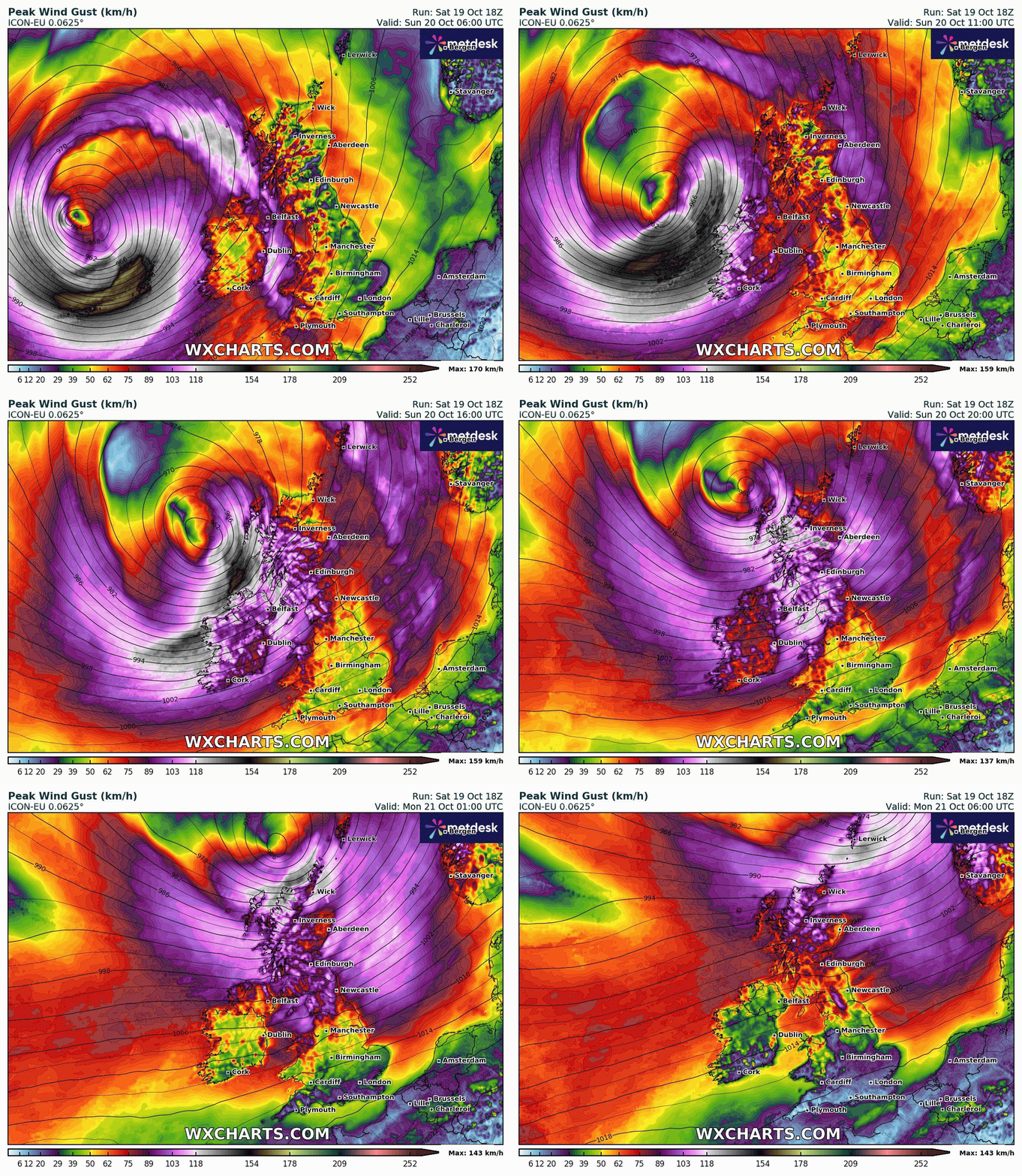
The first period or strong winds move through this morning with a brief lull in condition ahead of the stronger winds from storm Ashley which will move into the west and northwest from around 9am/10am this morning with a sudden rise in the wind strength expected by midday.
Met Eireann have also brought there orange wind warning forward this morning which now starts at 10am.
There is also active thunderstorms expected across the west and northwest this morning and afternoon as the center of Ashley passes closely to the northwest. Very dangerous conditions can be expected especially when you combine the heavy showers and damaging winds.
Please do send in any updates to us today of trees down, roads closed, flooding and so on so we can warn others.
Further updates to follow
STORM ASHLEY UPDATE 22:34hrs - 19/10/24
Not much change in the evening model runs this evening. I do expect a Red Marine warning to be issued for coastal areas of the west and northwest in the coming hours.
Some of the other European models do show rather strong winds moving up across much of the country so we could see further orange warnings issued over the next few hours for places like Roscommon and even parts of Leinster. This storm will feel rather strong and the concern is the amount of leafs on trees which will mean trees will come down much easier than a winter storm.
I would expect lots of power outages across much of Ireland especially west Munster, Connacht and west Ulster.
Anyone planning to travel tomorrow please take great care as it will be rather dangerous especially across the western and northern half of Ireland.
Another risk on Sunday afternoon and evening will be very heavy convective showers with tornadic like wind streaks which can be very dangerous and damaging.
Winds will pick up after midnight with a period of strong winds moving up across Ireland through the morning.
The second wind event will then move into the west first on Sunday morning around 7am with winds increasing everywhere through the morning. Please note parts of Mayo and Galway could see orange level winds before the actual orange warning comes into place at midday so please be aware of this. Winds will remain strong throughout the whole afternoon and evening especially across the west and northwest.
Please also stay away from all coasts as there is a big risk of coastal flooding especially with the very high spring tides expected combined with the strong winds.
Further updates to follow
STORM ASHLEY UPDATE 18:30hrs - 19/10/24
Storm Ashley continues to rapidly develop this evening with explosive cyclogenesis. Status Orange wind warnings are now in place for Donegal, Galway Mayo, Sligo, Leitrim, Clare & Kerry from 12:00hrs Sunday to 20:00hrs Sunday.
Full update to come later.
STORM ASHLEY UPDATE 9:33hrs - 19/10/24
Storm Ashley is currently developing out in the Atlantic this morning and rapidly intensifying and will become a very strong storm over the coming hour. Below I have marked the position of the storm this morning. Updates to warnings can also not be ruled out.
STORM ASHLEY UPDATE 9:33hrs - 19/10/24
Warnings this morning have been updated and Donegal & Clare have been added to the orange warning for wind. Further updates to this warning are still likely.
STORM ASHLEY UPDATE 21:33hrs - 18/10/24
Storm Ashley will start to develop out in the Atlantic on Saturday morning and undergo rapid cyclogenesis with pressure falling more than 24hPa in a 24 hour period with the centre and the core of the storm deepening. It will then push west towards Ireland and pass to the west and northwest Sunday morning, afternoon and evening.


